Wednesday, September 29, 2010

a short walk in the San Gabriels

Monrovia Canyon Park

monrovia falls
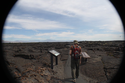
Back in August during a visit with friends in Glendale, CA we had an afternoon that called out for a hike. The Station fire last year burned most of our favorite short hikes in the West end of the San Gabriel Mountains and Angeles Crest Highway remains closed until further notice. I have not seen it in person but I hear tell the heat of the fire vaporized all the guard rails, signs, and some of the asphalt.

Monrovia Canyon Park is far enough East to be out of the burn area and it offered one of the few San Gabriel foothill hikes within a short drive of Glendale that was still open.
over the river...
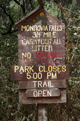
There is a per car fee of $5 and maps available at the entrance to the park. The map will guide you to one of several parking areas depending on what trail or picnic area you wish to visit. With kids in tow we chose the short 3/4 mile walk to Monrovia Fall(s). This is a popular trail with dog walkers so expect company particularly on pleasant weekend afternoons. The trail winds up the canyon crossing the creek several times. Some tip-toe rock balancing is required to cross the water but the rest of the trail is well maintained and an easy grade.
and through the woods...
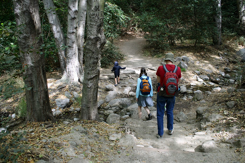
There's the magic adventure bag, the ever present companion. Restroom facilities are available near the parking area but none up the trail so don't forget your pee style ladies.
faterwall!
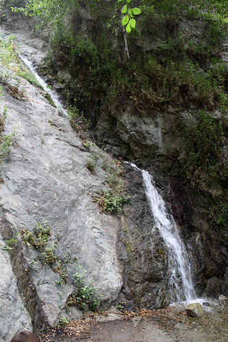
At the end of the trail you'll find at least a smidgen of a waterfall even in the summer. If you make the trek after a good rain (yes, they come once in a while in LA) the waterfall will be more impressive and the creek crossings more harrowing. Beware, if you hike on a day that threatens imminent rainfall, the canyons of the San Gabriel Mountains are notorious for flash floods and debris flows of mud, rocks, and trees.

All said, we had a pleasant short hike that kept the kids busy enough poking in the water. After a lunch snack near the small waterfall we headed back downstream. If you go, keep an eye out for the peculiar glazed ceramic trail markers.
16
We never figured what the numbers indicated. Maybe you can sleuth it out.

Thursday, September 23, 2010

trailing bob jones

Sorry folks, this is about an easy hike/bike trail near San Luis Obispo, CA named for a central coast conservation activist not the evangelist namesake of Bob Jones University.

If you live near or are visiting San Luis Obispo here's an excellent choice for a nice walk or an easy bike ride. The a-go-gos and most of the family were looking for a bike ride that everyone could manage including the nephew a-go-go who's legs are still short. The Bob Jones City to Sea Trail fit the bill nicely. Here are directions and a map. and for the curious here's some tidbits about the man and the eventual plan for the trail. For now the trail is only 1.5 miles but some day it will connect the city of San Luis Obispo with Avila Beach.
ring ring

If you want to make the short journey on a weekend it's a good idea to arrive early. The parking area is small and will likely fill by 10am on nice weekend mornings. We set out at 8:30 when the typical summer coastal fog was still drifting over the hills. That kept us nice and cool until about 11am on our way back.

The trail winds along San Luis Obispo Creek though it isn't visible much of the way. We've made this short trek before and are still fascinated by the stalled development pictured above (this is a picture from a year ago on a day with no fog). The steel columns look like something out of a Time Machine film set. Much of the canyon is developed and the trail skirts some condo clusters, a Buddhist temple, and a golf course but it is still a pretty ride.
 
 On our way to Avila we passed several joggers and dog walkers. By the time we were headed back the trail was quite a dog party and people were neglecting the "keep right" policy causing a little chaos. After about 3/4 mile the trail comes in view of the creek and joins Blue Heron Drive. This is an active road shared with auto traffic though the speed limit is 20mph and the drivers were all very courteous and patient with the pedestrians and bikes.

After leaving Blue Heron Drive the trail meanders through the golf greens, crosses the creek on a small truss bridge, and ends at a pedestrian crossing of Avila Beach Drive. If you wish you can continue on Avila Beach Drive. It skirts the bay and dead ends at the pier on the West side. The sea lions are often hanging around barking and growling at each other and there's the Olde Port Inn at the end of the pier.

We chose to continue on San Miguel Street which leads to Avila's beach front walkway. Lining Front Street there are several places to get a cup of coffee, a dab of ice cream, or a sandwich.

We locked up the bikes (One thing missing here is bike racks. There are a couple here and there but most people seem to use the railing along the walkway.) and took a walk out to the end of Avila Pier (this one's on the East side of the bay). The fog was still with us so our photos are mostly of things fading to white, but mrs. a-go-go got some excellent shots of dew spangled spider webs.
The pier was just long enough and the fog just thick enough that we seemed to be taking a bridge to nowhere. Looking back from the far end the shore faded into a faint horizon.
Morning fog and cool temperatures is the norm for a summer day at Avila, but any time of year is a good time to visit. Often the best beach days here are in the Fall and Spring, so put that bike on the rack and go. For those with more muscles and more ambition the ride from San Luis Obispo to Avila can be made on the asphalt even though the future dream of the City to Sea Trail is incomplete. It's only about 10 miles. C'mon you can do it.

Thursday, September 16, 2010

mo' betta mummies

California Science Center and Mummies of the World

In August we had a visit to Los Angeles, our old stomping grounds, and took in Mummies of the World, a temporary special exhibit at the California Science Center. We were joined by the sister a-go-go and the nephew a-go-go. For hours, directions, and admission info do check on the links above but here's a few tips gleaned from our visit...
The web site is unfortunately being vague about the closing date for the show. They say it ends in the Fall some time. Yes, but WHEN? If you want to see the show while it's in Los Angeles be sure to check and double check the web site to be certain that the exhibit is still running. As of today, I can't seem to find a closing date anywhere. Admission to the California Science Center is normally free, but this is a special show so the tickets are a little pricey. The standard adult admission is $21.50 (if you buy them online). mrs. a-go-go did some internet digging and found a special coupon offer that let us buy adult tickets at the box office for $16. Sorry I don't have a link for that coupon, it was a limited time thing and seems to have dried up. Next is parking. It is possible to find parking in the neighborhood around Exposition Park but your time is likely to be limited to a few hours. The parking lot for the museums is normally $8 per car but the fee is sometimes more if there is a big event. If you use the museum lot beware that the entrance to the parking garage is a hard right immediately passed the parking attendant. If you miss it you have to circle the park again to get back.
Shew! OK, on to the exhibit. Sorry, photography is not allowed in the show, so I'm a bit short on images here. We went on a Friday morning near opening time and the crowd was not too bad. With the exhibit nearing the end of its run things could be heating up and the crowds thicker, particularly on the weekends. There were a few waits to get close to some cases but not enough to get frustrating. The collection of mummies and the wealth of didactic material for the show is marvelous and there was a reasonable amount of space around most of the displays, but the display heights are not designed with kids in mind. If you go with the young'uns be ready to do some lifting so they can get a better look. The show begins with a collection of mummified animals. This provided a good illustration of a key point of the show, that there are natural mummies and then there are the standard mummies that we all think of right away, all those carefully prepared bodies wrapped in linen and some housed in an ornate sarcophagus. The mummified animals provided a good illustration of how common mummification is without the intervention of human handiwork. These naturally mummified animals all died in conditions where their bodies dried quickly enough to thwart the decay of skin and some fleshy bits. There was a house cat that had dried up in a drafty crawl space under a house, and a hyena that had dried on the savanna after being partly scavenged by big critters. These examples were all missing their hair and most of the internal bits had been consumed by the usual rabble of small scavenging critters, but the skins were generally intact and wizened. The leathery dry and hairless skins were shrunken and stretched over the ribs and pelvic bones, and the faces were all contorted into startled grimaces.

So these are natural mummies, I get it, lets move on to the Egyptian stuff. I wanna see some golden masks, and dried up bandages!... Ah, not so fast. There is actually very little of that sort of thing in this show, and if it is what you are after you will be disappointed. There is one Egyptian mummy of a wealthy individual complete with a decorated sarcophagus and bandage wrapped body with crossed arms, but the bulk of the show is not focused on this sort of thing. At the beginning of the Egyptian section there was another collection of mummified animals, these having been purposely mummified by the Egyptians to serve as companions to the people mummies. There were lots of cats, a cayman, and a snake among the menagerie all wrapped up in lumpy bundles and a few that had been decorated to look like the animal in life. These gave a good counterpoint to the naturally mummified animals that we had just seen driving home the difference between a natural mummy and one that had been prepared carefully for burial.

The rest of the show is divided by the parts of the world where the mummies were found, and most of these examples are actually classified as natural mummies, even when they were purposefully buried. For example, one of the collections is a group of Europeans who were interred in a crypt that just happened to be cold and drafty enough to thoroughly preserve the bodies. I suppose that in most cases the bodies would decay to little more than bones with the help of rats, maggots, and bacteria but with all the water sucked out of 'em right away they became these unintended oddities with weird toothy grins. This is the sort of thing that I can see leading to legends of the undead and vampires. Apparently some of these natural mummies became tourist attractions for a while in their European crypts.

There were natural mummies from South America, who may have intentionally been buried high in the Andes where people knew they would dry out, but they are still considered natural, and bog bodies with black tanned leather skins and spongy rubbery black bones. There were fantastic interactive digital displays that exhibited three dimensional imaging of selected mummy's interior. There were late Hellenistic Egyptian mummies that had been entirely stripped of their bandages. And more....

All in all a good show, and worth the trouble, but I am glad we found the discounted tickets.
Later, we did some mummy making of our own with the nephew a-go-go.

The California Science Center has a whole lotta stuff to offer beyond their temporary shows like Mummies of the World. In the last year a large new wing of permanent exhibits was opened and admission to all of this part of the museum is free.
This new wing is mostly filled with the Ecosystems galleries. These are divided into zones including the Rot Room (HA! I have one of those at home.) and the big aquarium tank pictured above. After our date with the mummies we didn't have time to explore all the new stuff so we will be back for more soon.
If you're in LA and have a day to spend watching jellyfish swim and making sequins shimmer don't miss the Science Center. It'll keep you busy all day even without the mess of mummies.

Saturday, September 11, 2010

bounce it off your satellite

GPS vs. MaPS
cards and maps
Finding one's way on the road has changed dramatically. GPS devices and internet offerings like MapQuest and Google Maps threaten to put the old paper map books out to pasture, and maybe I'll never have to ask people on the street for directions ever again.

Yeah, maybe not. All the new fangled stuff certainly helped us on our trip but we couldn't have made it with out the trusty Michelin North America road map book, our collection of ancient technology folded paper AAA maps, and a few scribbled out hand drawn maps.

A friend and former neighbor loaned us her Garmin GPS unit for the trip. It came with the caveat that it was far from infallible. It had been known to send the driver down unmarked dirt roads or show the vehicle gliding over blue digital lakes. After listening to the now common female electronic voice repeat, "Recalculating." quite a few times we knew the GPS needed a nick name. By our second week into the trip the name that stuck was LaFonduh. Not that she really had anything in common with the character in Napoleon Dynamite, but she did arrive from out of town one day like a blind date and changed our lives in unpredictable ways. She couldn't stick around after the Big Trip, and she is on her way back home now.

LaFonduh gave us quite a few bum steers and many confusing or potentially dangerous directions, but she did none the less make many fine contributions to our travels. After all the recalculating and comical electronic mispronunciations we think it would be worth investing in a LaFonduh of our very own for our next big outing. She gave us helpful estimates of arrival times, she provided detail maps and local directions in places where our paper maps came up short, and she was indispensable in tracking down specific addresses in far away towns. We used ATM machines quite often on our trip and finding a local one was always an adventure. Our bank's website provided locations of ATMs where we could supposedly make fee free transactions and we'd hand the addresses over to LaFonduh. Now, some of the information given by the bank was honestly way off target and we ended up in some strange parts of towns looking for Federal Credit Unions or local banks, but a few times the fault was clearly LaFonduh's leading us to streets lacking signage, sidewalks, or pavement in search of a Brigadoon ATM. All said and done though, LaFonduh was a good addition to the crew and a boon to the trip.
the border
I have heard rumblings about the GPS system being in disrepair and with lack of funds for new satellites it may become a bit more unreliable and less accurate some time in the not too distant future. For those of you unfamiliar with the nuts and bolts of GPS, the little talking screens are dependant on the radio signals from a constellation of geosynchronous orbiting satellites to calculate the position of the individual hand held device to within a few feet. Apparently the satellites have an expected service life and the original plan called for launching new satellites on a specific schedule to take the place of the aging ones. Well, economics and budgets being what they are the schedule has had many postponements. The good news is that most of the satellites have been outperforming their expected life span and there are still a few spares in the system to keep up the minimum number for global coverage. On the bad side it seems that we in the technologically advanced world have been getting more and more dependant on the GPS system, and it could start showing cracks leaving us staring at little boxes that repeat, "lost satellite reception." while the little digital car wobbles on a big green trapezoid.

For finding the local hot dog place in Northwest Connecticut where we had no local maps (it was closed when we got there, rats!) LaFonduh was indispensable, but we were never without our Michelin map book. We kept it at the ready when ever we were driving. It kept us on track and did an excellent job as the authority that could confirm or reject LaFonduh's directions. The book made our daily planning easier and provided a good place to draw the pink line tracing our route, plus it never ran out of batteries or lost satellite reception. It gave excellent advice on scenic routes and made finding back road alternates to the interstates (that LaFonduh worked feverishly to steer us away from) much easier.

GPS is swell but map reading, using a compass, and planning where we are going is becoming a lost art. Those muscles are atrophying way to quick. One of mrs. a-go-gos favorite anecdotes concerns being asked for directions one day in Los Angeles. She was hailed in a parking lot by a driver in a shiny white BMW who was lost and in a hurry. He was asking for directions to an intersection of two major streets and muttered about a meeting for which he was late and worried. While he fussed, mrs. a-go-go did her best to point him in the right direction and offered to retrieve our Thomas Guide map book to find which intersection he ment. Then, frustrated, he said, "Never mind, I've got it on my GPS." and sped off. As the dust cleared mrs. a-go-go shook her head. He was clearly going in the wrong direction and would be late for his "meeting." (Hmm... guy in a new BMW needs to meet someone at an intersection at 11 am.) The intersection he was seeking happened to be on two streets that wind very far across LA and intersect at least three times in places very far apart. Hope that guy wasn't meeting with someone who would fit him with cement overshoes. Oh well, he should have looked things up on a map ahead of time.

The shrivelling art of reading maps is a cryin' shame. I'm sure some of us will keep it alive until all the batteries die, at least I hope we will. I'm no stellar navigator and have never owned a sextant (though I've always been fascinated by them), but I can still use a compass and make a good guess where I am on a decent map, and I can find Polaris if the city lights are far enough away.

On our visit to the Montreal Museum of Archaeology and History we saw an exhibit about Rapa Nui that included this example, below, of the maps that the Polynesian navigators made to record the location and/or direction of other islands across hundreds if not thousands of miles of open ocean. I'm still boggled by the thought that these folks could cross such spaces with little to guide them other than the stars and the wave patterns reflected from distant islands.
a stick map

Wednesday, September 8, 2010

it's in the bag

the adventure bag, don't go walkin' without it .
the adventure bag
You may have spotted this red and grey bag riding on my back in many of mrs. a-go-gos photos on the trail. Yes folks, that is the veritable Adventure Bag in all its glory. We do our best to keep this bag stocked and ready for the trail whether it's in the trunk or in the closet at home. It makes life easy when we have a spontaneous need to get out for a day hike or when an unexpected state park pops up where the road leaps over the next hill.

The adventure bag keeps us hydrated, supplied with snacks, soothes boo-boos and insect bites, and helps keep mrs. a-go-gos pants up when she has to pee in the woods. So what's in the magical bag of tricks?
yellowstone adventure bag
Here's the standard stuff that lives in the bag:
*small flashlight (maglite)
*pocket knife (Get one with a knife that is at least 2 inches. The more gizmos on your knife the better but my favorite has a three inch blade, can opener, bottle opener/flat blade screwdriver, and an awl[you'd be surprised how many holes I have had to poke through things with this.] It doesn't have to be a Victorinox but if it's a cheapie make sure the blade won't fold on you when you need it.)
*a compass (learn to use one folks)
*2 whistles (we wear these when out walking, never know when you need to make a loud noise)
*one pen and one pencil (the old wood style) and a small note book
*a few wet wipes (hate the packaging but every little once in a while we need 'em)
*a couple of used plastic bags for picking up trail trash
*a small magnifying glass (we have a 2 inch all plastic one for tiny things on the map and for seeing bugs and splinters)
*a tiny sewing kit (the kind that some motels still provide, but all you need is a good needle and some thread)
*matches (something water proof, I have a little sealed metal cylinder with about twelve strike anywhere matches)
*two bandannas (for all sorts of things, when it's hot get it wet and tie it on your neck, napkin, bandage, mask for cold wind [no joke, this got me through the day up on top of Mt. San Antonio last year], and to tie up your hair when it gets all sweaty and ick.
*small bottle of hand sanitizer
*a small emergency water filter (we have one of the straw types that you can sip through)
*a space blanket
*lip balm
*sunscreen
*first aid kit (moleskin for hot spots [remember to put it on before you get a blister], small tweezers, a mess of band aids, some small antiseptic packets, some hydrocortizone for bites and itches, one of those bite sticks like biteMD, and some pain pills whatever is your favorite)
*two nylon windbreakers (these are compact and are great to throw on as a wind shell, but do bring some other warm layer too, we like to have a synthetic fleece something or other)
*durable snacks (gum, nuts, fruit leather, or granola bars)
*some TP and/or a pack of tissues
*last but not least, a pee-style for the ladies and some sort of zip lock bag to keep it in.

Before we step out on the trail we add full water bottles, lunch, a map if we are going far, the cell phone, and the gorilla pod (a compact tripod, mrs. a-go-go keeps the camera on her shoulder) and we are on our way. Don't forget that extra warm layer or a sun shirt, and do wear your hat and sun glasses.
another sighting of the adventure bag
Put a bag together. It'll yell, "Go on! walk up that hill!" the next time you see an inviting meadow.

Sunday, September 5, 2010

just the facts ma'am

The Big Trip is over but there will be more to come. If anything, seeing all these places and meeting all these new friends has produced an appetite for more. The list of places we missed is far longer that what we did see, and we have a growing list of places to visit again. It will be a while before we have the time and budget for another long trip, meanwhile lets see how we did. If you don't care for figures and budgets this post is not for you, but if you wish to know the dirty details, read on.
After checking over the map and all the notes in our log book here are the facts:

time on the road: 12 weeks and 3 three days, or 87 days total

Rodney's odometer: 11,673 miles, an average of about 134 miles/day

the dough: $6,156 total, $495/week average, $71/day average

the gas: $988 for approximately 330 gallons and an average of 34 mpg. (not bad for a 1999 Rav4 that is only supposed to get 28 mpg.)

two oil changes on the road: $123.78 (that was all Rodney needed on the trip, but we invested about $150 for parts pluss some sweat equity for preventative maintenance before starting down the road)

18 nights in motels: $1,262, average $70/night

13 nights camping out: $190, average $15/night

56 nights on the hospitality of friends (and family): $0, but this should be a negative number, because we received so much more than just places to sleep. This would have been a very different trip if not for the generosity of so many people.

How does all this compare to the original plan? Surprisingly well. After putting pins in our map for all the places we wanted to visit, and more importantly, for all the people we wanted to visit we made a rough itinerary and made a guess at what we would spend. We figured on a minimum of 10 weeks on the road, a budget between $5,000 and $7,000, and a distance of about 10,000 miles. Our actual average spending of $495/week miraculously hit the target dead center. Until we were home and I had added things up I had no idea that we had stayed so close to the plan.

We tried to plan our destinations so that the drive times were four hours or less per day. For most of the trip that was true but we did have some marathons. The first was the stretch from Marfa to Austin, Texas. That was about eight hours. There were others but none compared to our last stretch home when we had simply had enough and wanted to be home. That last day of 14.5 hours of driving in a 16 hour day took the cake.

I had imagined that we would spend more time camping out, but with threatening weather and the pain in the neck of breaking camp after one night (in most cases) we just didn't have the energy on too many evenings and we'd settle for a motel. Those of you who have been reading along since the beginning may remember our Transit Connect dream. It's a small commercial van from Ford that I thought would make a swell tiny camper. If that had come true we would have spent more time in camp sites. Having a ready made bed makes things much easier than setting up a tent for the night.

I have to say again that no such trip in this budget would ever have been possible without the generosity of our many hosts. We slept on couches, air mattresses and floors, we were well fed, and well entertained, and we managed several loads of laundry along the way. Our impressions of the many places we visited were richly flavored by the people who took us in and showed us their stomping grounds. We can not thank them enough. In addition, we were buoyed by the generous support and gifts of many others who helped us make our way down the road.
The pink line on the map has brought us back to California, but the rest of that open space is calling. Maybe we can get our hands on a Transit Connect some day soon and make the long loop of the Southwest. Heck, we could spend a year in New Mexico alone... Hmm, I need a job first, at least for a while.

Saturday, September 4, 2010

Home At Last

California 8/5
we returned home from our trip to this lovely package from some favorite people. who could have asked for a better return. now what?

Friday, September 3, 2010

one last driving marathon

8/4 Portland to Home

Up early, packed up, and in the car by 7am. Why is the last day of any road trip always a long long drive? We were suffering from serious travel fatigue in our last week on the road so I suppose doing the last leg in one go was inevitable. We had thoughts of trying to visit one more friend in Santa Cruz on our way south or possibly stopping for the Underground Gardens in Fresno, but the thought of one more night in a motel just filled us with dread. So... 14 hours of driving in one day? No sweat. The last three months had me well prepared for the task.
There is little to say about the drive. It was just long, and in fact I remember very little of it. With the end traveling in sight very little mattered other than staying awake all the way home. Shasta greeted us South of the California border and threw us into the Central Valley. I think lunch was had in the car while driving and other than stopping for gas and a few leg stretches our only pit stop was dinner at Denny's in Red Bluff.
We slogged our way through traffic West of the bay area and hopped on the 101 near San Jose. As night fell some low clouds and fog turned up on the road ahead. It made me think of all the unknowns coming for us at the end of the road; no jobs, no home, no real plan. Oh well, we had chosen to take this grand tour knowing what we would have to give up. Now we'd just have to dig in and get to work.

As the headlights came on we figured that if fatigue set in and threatened to send us into the ditch, a stop for the night would be OK, but that never happened. This marathon went very smoothly and we made it home by 11pm.
Here we are in the morning after our 16 hour day. Unloading Rodney and sorting the pile would just be the first step on the next journey.

Thursday, September 2, 2010

portland a-go-gos

Oregon 8/2-8/3
well folks, this is truly the last leg of our crazy journey. we rolled into portland like mr.a-go-go wrote ready to see some favorite people yet so so so ready to be home. it was as if the travel fatigue fairy walloped up on our noggins, we were that eager to be home but first we would visit.sadly, as it was summer, these lovely people were on their very own road trip so we were unable to squeeze each other and make a mad dash for the booth. luckily for us though, we were mere moments away from visiting with these lovely people as they were getting ready to journey out themselves. phew! talk about timing! we may have had only a day and a half but it was oh-so-nice to hug and squeeze and chat, chat, chat away. it was so lovely to play catch up and see how the young miss had grown.there was crafty talk, catch up talk, errand running, taco truck snacking, home cooked meal enjoying and some major scone scarfing. susan and family eventually squeezed out the door for their own adventure leaving us another night in their lovely home (with our very own jar of home made jam).we took the day s l o w l y. laundry was finished, photos were uploaded, books were read and banh mi was sought out. we wondered if we would camp on the way down. would we take this route or that route. would we see friends here or there or would we take the plunge and drive straight through? this was the end of our trip...the end of our trip! it felt at once exciting, thrilling and completely without luster. darn that trip fatigue fairy. even as we slooped into the guest bed all made up with vintage bedding we still hadn't figured it out. the morning would see us through and so we slept.

Wednesday, September 1, 2010

an oregon beach day

Oregon Coast 8/1
we woke up bright eyed and ready for something. we need to explore for a few hours before Susan and family would be home for us to visit with back at their casa. we decided a beach day would be a good thing as last time we came to oregon we never got to see the coast so after loading up Rodney we were off!

we took the time for the scenic route and bypassed the big highway. while it may have added almost an hour to our drive it was worth as there were berries involved.and yes, we picked some. how could we not? we even picked up a few blackberries. i think blueberry picking may be one of our most favorite things on this trip. after all we are now old pros at it. mr. a-go-g is now looking at bushes to see if we can grow some at "home".we drove for what seemed like forever, past sleepy towns, a coastal train and the Tillamook Cheese Factory! eventually, hunger ruled and we pulled into a spot high above the sands below and trekked down for a seaside lunch and mayhaps even a nap.the weather was perfect. not too cold, not too hot and the beach was perfectly populated. we enjoyed ourselves immensely. eventually we packed up and made the wee trek back to the car to explore the rest of what the coast had to offer.we had hoped to make it to Astoria but found we lacked time in that department so instead we took a peek at the road food book to see if there was anything nearby. there was, so we turned onto a popular street that took us through the even more popular town of Seaside. the spot we were fixin' to find was gone but there was enough to see and a parking spot right in front of us.serendipity! we pulled in and wandered checking out the carousel and the candy store. eschewing the really, really good fudge, we settled for a scoop each and licked it all up before it melted. now, finally, it was time to head to our portland home.

LinkWithin

Related Posts with Thumbnails