

Finding one's way on the road has changed dramatically. GPS devices and internet offerings like MapQuest and Google Maps threaten to put the old paper map books out to pasture, and maybe I'll never have to ask people on the street for directions ever again.
Yeah, maybe not. All the new fangled stuff certainly helped us on our trip but we couldn't have made it with out the trusty Michelin North America road map book, our collection of ancient technology folded paper AAA maps, and a few scribbled out hand drawn maps.
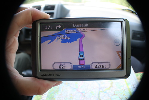
A friend and former neighbor loaned us her Garmin GPS unit for the trip. It came with the caveat that it was far from infallible. It had been known to send the driver down unmarked dirt roads or show the vehicle gliding over blue digital lakes. After listening to the now common female electronic voice repeat, "Recalculating." quite a few times we knew the GPS needed a nick name. By our second week into the trip the name that stuck was LaFonduh. Not that she really had anything in common with the character in Napoleon Dynamite, but she did arrive from out of town one day like a blind date and changed our lives in unpredictable ways. She couldn't stick around after the Big Trip, and she is on her way back home now.
LaFonduh gave us quite a few bum steers and many confusing or potentially dangerous directions, but she did none the less make many fine contributions to our travels. After all the recalculating and comical electronic mispronunciations we think it would be worth investing in a LaFonduh of our very own for our next big outing. She gave us helpful estimates of arrival times, she provided detail maps and local directions in places where our paper maps came up short, and she was indispensable in tracking down specific addresses in far away towns. We used ATM machines quite often on our trip and finding a local one was always an adventure. Our bank's website provided locations of ATMs where we could supposedly make fee free transactions and we'd hand the addresses over to LaFonduh. Now, some of the information given by the bank was honestly way off target and we ended up in some strange parts of towns looking for Federal Credit Unions or local banks, but a few times the fault was clearly LaFonduh's leading us to streets lacking signage, sidewalks, or pavement in search of a Brigadoon ATM. All said and done though, LaFonduh was a good addition to the crew and a boon to the trip.
I have heard rumblings about the GPS system being in disrepair and with lack of funds for new satellites it may become a bit more unreliable and less accurate some time in the not too distant future. For those of you unfamiliar with the nuts and bolts of GPS, the little talking screens are dependant on the radio signals from a constellation of geosynchronous orbiting satellites to calculate the position of the individual hand held device to within a few feet. Apparently the satellites have an expected service life and the original plan called for launching new satellites on a specific schedule to take the place of the aging ones. Well, economics and budgets being what they are the schedule has had many postponements. The good news is that most of the satellites have been outperforming their expected life span and there are still a few spares in the system to keep up the minimum number for global coverage. On the bad side it seems that we in the technologically advanced world have been getting more and more dependant on the GPS system, and it could start showing cracks leaving us staring at little boxes that repeat, "lost satellite reception." while the little digital car wobbles on a big green trapezoid.
For finding the local hot dog place in Northwest Connecticut where we had no local maps (it was closed when we got there, rats!) LaFonduh was indispensable, but we were never without our Michelin map book. We kept it at the ready when ever we were driving. It kept us on track and did an excellent job as the authority that could confirm or reject LaFonduh's directions. The book made our daily planning easier and provided a good place to draw the pink line tracing our route, plus it never ran out of batteries or lost satellite reception. It gave excellent advice on scenic routes and made finding back road alternates to the interstates (that LaFonduh worked feverishly to steer us away from) much easier.
GPS is swell but map reading, using a compass, and planning where we are going is becoming a lost art. Those muscles are atrophying way to quick. One of mrs. a-go-gos favorite anecdotes concerns being asked for directions one day in Los Angeles. She was hailed in a parking lot by a driver in a shiny white BMW who was lost and in a hurry. He was asking for directions to an intersection of two major streets and muttered about a meeting for which he was late and worried. While he fussed, mrs. a-go-go did her best to point him in the right direction and offered to retrieve our Thomas Guide map book to find which intersection he ment. Then, frustrated, he said, "Never mind, I've got it on my GPS." and sped off. As the dust cleared mrs. a-go-go shook her head. He was clearly going in the wrong direction and would be late for his "meeting." (Hmm... guy in a new BMW needs to meet someone at an intersection at 11 am.) The intersection he was seeking happened to be on two streets that wind very far across LA and intersect at least three times in places very far apart. Hope that guy wasn't meeting with someone who would fit him with cement overshoes. Oh well, he should have looked things up on a map ahead of time.
The shrivelling art of reading maps is a cryin' shame. I'm sure some of us will keep it alive until all the batteries die, at least I hope we will. I'm no stellar navigator and have never owned a sextant (though I've always been fascinated by them), but I can still use a compass and make a good guess where I am on a decent map, and I can find Polaris if the city lights are far enough away.
On our visit to the Montreal Museum of Archaeology and History we saw an exhibit about Rapa Nui that included this example, below, of the maps that the Polynesian navigators made to record the location and/or direction of other islands across hundreds if not thousands of miles of open ocean. I'm still boggled by the thought that these folks could cross such spaces with little to guide them other than the stars and the wave patterns reflected from distant islands.

I recently had this discussion with friends. My husband is terrible with directions while I am the one with the inner compass and road memory. I thought of buying him a GPS but thought he'd be distracted by it. Friends recently bought a GPS and love it. It helped them branch off of highways and travel more scenic routes. When they asked of anyone else used a GPS, one friend answered, "Yes. I use a M.A.P." Another answered, "I have an upgraded version called an A.T.L.A.S."
ReplyDeleteI'll be sticking to my old school methods and relying on my road memory and inner compass ;)
I'm with Min, I have the inner compass. Fortunately I have a wonderful husband but he can't find his way anywhere. Luckily I'm great at it....hey, it's a good skill to have!
ReplyDeleteBTW go-go's, I made parts of my family do a jump shot on the beach. I enjoyed it, my sister - loved it, my husband will never do it again and my brother is a good jumper...hahaha
Thanks for the new tradition!
My mum is having a hard time letting go of years gone by so I am quite comfortable with a map, Thomas guide and compass. It cracks me up whenever I say I'll check the Thomas Guide and one of my peers will ask, "What Thomas guy?" Love the information on the satellites, thank you. Off to google Rapa Nui.
ReplyDelete